
|
A collaborative project was initiated into the social processes and technical means to make multimedia a viable tool for planning and decision making at the community level. Fuller's idea of a World Game as a simulation of "what if" questions, updated by the use of expert systems, multimedia and simulation models is proposed as a model for ecologically sustainable development planning. This model encourages the ownership of the planning system by the community and uses action research methods to provide feedback, formative evaluation and ongoing redesign. The involvement of women in this process will be actively encouraged.
Social, economic and environmental problems such as unemployment, urban sprawl and loss of biodiversity require solutions through the invention of social technologies. Examples of emerging social technologies are conflict resolution, systematic public consultation/ participation, technology assessment and decision conferencing (Cocks, 1992). Existing social technologies include land rights legislation, the taxation system and Land Care groups. While such social innovations have had some degree of success, further research is required to develop more effective participative processes which allow people to take self responsibility and encourage organisations to change towards a more empowering and cooperative paradigm.
Strategies for planning ESD such as Integrated Catchment Management (ICM), Land Care and the Better Cities program, are currently being implemented around Australia. Related programs such as Integrated Local Area Planning have been proposed (Australian Local Government Association, 1992). Trends towards participative educational and organisational systems and the increasing influence of non-government interest groups are placing demands on government and industry for the development of processes which involve all stakeholders in decision making. ESD can be seen as a new goal for planning which requires innovative strategies to find solutions to complex problems such as land degradation, decreased quality of life and unemployment.
This paper outlines the context, philosophy and initial development of an innovative program which aims to design and evaluate a new social technology: an interactive computer mediated process which will enable local and State governments, industry and the local community to effectively envision and plan ESD strategies. A flexible process will be developed, based on action learning principles, which actively involves the community and meets social justice requirements such as gender equity. The program is based in rapidly growing Caboolture Shire in South East Queensland.
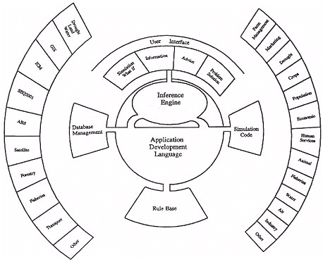
One of this partners in this collaborative program, Queensland Supercomputing Laboratories (QSL), is currently developing a new Interactive Resource Management System, using the "Mosaics" Applications Development Language produced by CADCOM (Harvey, personal communication, 1992). We will soon have the capacity to connect up data that has been available as long as we have been recording it. This would allow us to approximate whole systems models. Using a model such as Stone et al's (1986), Mosaics could be the interface for a very complete simulation/expert system with multimedia user interface, as shown in Figure 1.
In the past, simulations have been confined to specific systems, such as fish stock breeding cycles and pest management. With the new enhanced capacities we will soon be able to model all known data about a specific location - land, vegetation stock, air, water, human habitation, infrastructure, demographic, employment patterns, economics, health and human services. This will provide the capacity to ask "what if" questions about whole bioregions. While this technology develops, each new version moves closer to the whole systems model.
The capacity to do this has an impact on our mindset that is equivalent to the revolution of round earth thinking. This is exciting and yet it has its dangers. Bureaucratic needs will tend to isolate such a process from the users. An argument can easily be constructed to support the efficiency of centralising such complex information. Yet, if an advance like this is to reach its full potential, it does so best, if more messily, in the hands of the community whose needs it addresses.
At the moment this planning process is handled by separate and distant authorities, and some are not handled at all. However, if this integrated data were available to strategic decision makers, government Planners, producers and community members alike, they can envisage the full context of situational variables. This has the potential to change people's thinking, interrelating, decisions and action.
This World Game was effectively the first world simulation and as such a breakthrough innovation in social technology. Reports of this simulation are that participants generally responded with great enthusiasm and conviction. They often reported a new perspective or way of looking at world Problem (World Game Institute, 1991). An example of this was the idea of linking all the world electricity grids through sea cables to create energy interdependence and presumably facilitate more international cooperation and communication.
New developments in computer technology can enhance many aspects of the World Game idea. These tools have an imminent application in a global simulation or large scale simulation. It should be kept in mind though that these technologies are not the simulation. The simulation is the social, interactive and very human process of getting people together to work conjointly towards the conception and solution of seemingly overwhelming problems. Decisions about how to use this technology need to be aimed at enhancing, supporting and developing this social process.
New information technologies provide a means of facilitating communication between stakeholders and increasing involvement in issues, thereby enhancing democracy and facilitating a sense of local ownership and responsibility for natural resources and public infrastructure. Visual information is also considered important in increasing understanding and meaning for public participation in design and planning (Kaplan & Kaplan, 1989). For example Hassell (1987) found that a highly visual gaming/simulation was more a more effective method of communication between designers of community facilities and users, than verbal discussion, and increased respondents' satisfaction with the participatory process.
Involvement and interactivity are key elements in producing personal and social change through increasing understanding and active participation in learning and decision making. However, research shows that such strategies can be difficult to implement because of psychological, social, cultural and other factors which are often not considered (Stevenson & Schmidt, 1992; Blackler & Brown 1986; Sheridan, 1989).
GIS linked to decision support systems have been used by scientists for land use planning which takes a policy oriented approach. More recently, computer based packages have been developed to facilitate community action planning for rehabilitating rural lands (Thomas, 1992). The Queensland Department of Primary Industries (QDPI) has also produced several decision support packages to assist farmers in long term planning and decision making. However no long term evaluations of such systems have been conducted and they have not been developed for use with diverse groups of users.
Griffiths (1985, 71) points out that:
Technology is competitive, aggressive and controlling because it is generated in a social context which is itself characterised by these values. Changing these values must be a part of a broader struggle.Rothschild (1983), Pacey (1983) and others argue that by including women's distinctive knowledge and ideas in these processes, more creative and humanistic uses for such technologies would emerge. However we also need to consider the possibility of social change based on a transformation of gender relations, and to take into account "the broader web of economic, social and political relationships in which the technology is embedded" (Griffiths, 1985, 71).
Wajcman (1991, 166) suggests that:
Rather than calling for a technology based on feminine values, we need to go beyond masculinity and femininity to construct technology according to a completely different set of socially desirable values.With the realisation that our current systems based on competition, economic rationalism and technological determinism are no longer adequate, if not already in a state of collapse, alternative designs for work, living and learning, such as the one outlined here, are now emerging which embrace such values as cooperation ' creativity, sustainability, social justice and lifelong learning (Stevenson and Lennie, 1993). This philosophical stance is part of a new world view which is emerging through "systems thinking ecological concerns and awareness, feminism, education, as well as in the philosophy of human inquiry" (Reason, 1988, 3).
The Shire has been identified as a disadvantaged area, and has a diverse economic base, with agriculture producing $38.6 million of produce in 1989/90, and providing 7.3% of employment. Forestry and fisheries also play an important role in the Shire's economy. Its population has increased by 485% in the last 20 years and is expected to double by 2006. This rapid growth is anticipated to result in land degradation, high unemployment, and a conflict in land use.
The Council has a well managed GIS which contains a wealth of data and detail on the Shire's land use, soil types, legal boundaries etc, along with a significant database on population and human service trends. An ICM project has been established which aims to achieve the sustainable and balanced use of land, water and biological resources. In addition, significant efforts are already taking place in social, economic, tourism and environmental planning.
Caboolture Shire is currently planning an Environment and Heritage Centre in an area of remnant rainforest where the interactive planning system would be installed in the first instance. Inevitably, strategic decision makers will be the primary users of the most sophisticated results, but by embedding the system in the community it ensures that a range of possible flow on effects will occur. The aim is for the community to grow with the system.
The program is anticipated to take around five years to reach the stage of commercialisation and marketing for export. Major stages currently envisaged are:
Diverse groups of people will be brought together to make decisions about resources and planning, using DTM simulations and other visual information such as graphs and charts. The results of those decisions would then be displayed on screens for further consideration. Panoramic visualisations would eventually be developed which should enhance involvement and impact. The process used will include the training to make these systems available to all stakeholders. Some simplified examples of this mediated process are:
A process will be designed and evaluated which allows the people in the community to learn and self organise to prevent and repair environmental problems such as increased salinity, soil erosion and poor water quality and to find solutions to economic and community development issues. The process will be based on three principles identified by Morgan and Ramirez (1983, 4-9) which are needed to create self organising systems:
A variety of research and development methods will be used including workshops, focus groups, interviews, literature searches, expert and community panels reviews and other field work. The overall processes for community participation and the development of the interactive technology are shown in Figures 2, 3 and 4.
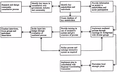
Figure 2
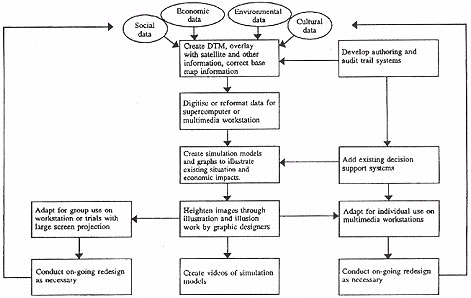
Figure 3
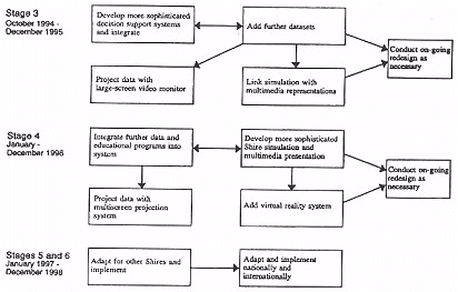
Figure 4
The aim would be to stimulate discussion and facilitate the involvement of all participants. A diversity of community representatives would be involved in this process, such as tourism development and Aboriginal and Islander associations, environmental groups, women's organisations, schools and community arts bodies.
State of the art software and hardware will be used to produce the simulations and graphic images required. Visualisation techniques will draw on live data to allow manipulation of images and graphics. This data will be linked to animated sequences, video and sound. PCs will be networked to a Unix workstation to facilitate rapid data transfer and seamless operation. High resolution colour maps and images will also be produced as hardcopy for use by the community. as well as for presentation graphics. An efficient archive and retrieval system will be developed and rigorously adhered to throughout the project.
The Digital Cadastral Data Base (DCDB) will be used as a reference frame on which to work, Shire Council, ABS and other data sets which could be used include:
| Economic and demographic data | Agricultural and environmental data | Social data |
|
|
|
From this presentation, the first pilot project was for QSL to develop a DTM of one of their river catchments, the Burpengary Creek area, and then load in the flood level data that existed manually to see what kind of visualisation they could create. Caboolture Shire Council provided us with some seed funding to conduct this part of the project and to develop the program further through preparing funding submissions and presentations to Queensland Government Departments which were potentially interested in becoming stakeholders. Along this path, we have discovered some interesting outcomes and principles, about the nature of the technologies we are using, the ways people find uses for them, and strategies for looking for funding.
Firstly we believe that the technology actually comes second: it's the ideas that people connect with that matters most. We now view the technology as a sort of honey pot, that will attract the bees in, and when they come searching they may find honey or something equally as interesting but different. Interestingly the idea of a community based interactive planning system has had some effects on the way some people look at how they do things. For example we have noticed that some Council staff have found the idea of a sustainable, eco-village based community more attractive after hearing about our system. To paraphrase one staff member: "When I put on my work hat I have to forget about what I might like or dream of, and do what has to he done. It may be that this system will allow some more of those dreams to happen."
Likewise, when we made our first presentation to Council and CSDA staff, some of them sat before us with blank faces and little discussion emerged. At our second meeting they asked questions about how we could hope to model something as complex as economics. We said that getting a simulation code that was perfect was impossible and not our aim, because we realise that the future cannot be predicted. What we could do, though, was to assemble the data with the best codes, models and expert systems that we could find or make, and use it to test out ideas about the consequences of actions or inactions. Trying to use the system as a machine that will give us the "ANSWER" results in selling it and ourselves short.
If we use it as a system that will provide a picture of the levels of photochemical smog from a third freeway lane, or project the numbers of human contacts using various transport means, or the economic effects of reducing farm chemical use, or changing cropping practices, all else being equal, a separate social effect is created. This other effect is to stimulate the imaginations of users. The images or projections (graphs, models or diagrams) will be representations of the effects of our decisions and they will also demonstrate the interdependence of the various levels of activity and specialities in the region. This is a tool to stimulate holistic thinking, not to do the thinking for us. So we are not looking for the economic answer as much as a medium to represent the complex interactions between ecological, social and economic factors and show us the outcomes in a graphic form.
Having explained this to Council staff on many occasions, a change started to occur. As they began to understand the idea, more of them became enthusiastic about it. The response at meetings was more open and interested. Also by focusing on the issues that they have nominated it becomes more and more something in their ownership.
The next learning is about the technology. This is a point that Peter Harvey from QSL has made. When they started loading in the data from Caboolture Shire they had trouble making it fit, because it was in the wrong format. The first useful outcome from these systems is that when they do not work they show us graphically the holes or errors in our data because this stands out clearly when data is visualised .
The third point that may be useful from our experience is strategies to attract funding. The majority of our time has been used up in researching, planning and writing funding submissions and preparing presentations for senior government staff. The two funding strategies we are following up are developing proposals for using the system to solve a specific problem that government has identified, or to down scale it into smaller building blocks. In the meantime we have assembled a team of interested researchers, postgraduate students and others from a variety of fields including, community consultation, supercomputing, graphic design, alternative economics, ecology, planning, alternative transport research, futures studies and social psychology to contribute to the eventual design and development of the system.
We are aiming to build a system in the community based on the needs and interests that the community expresses, such that a complex multi layered database is developed for one unique location. This in turn would create a powerful environment for the cross disciplinary cooperation that is in our assessment so vital to realistic, positive future change in our communities.
The findings from this study will hopefully provide new knowledge about the process for establishing, designing and maintaining participative learning communities. The model developed may be applied elsewhere to empower communities by extending citizens' capacities to take responsibility for actions and outcomes.
Arnold, E. & Faulkner, W. (1985). Smothered by invention: The masculinity of technology. In Faulkner, W. & Arnold, E. (eds.), Smothered by invention: Technology in women's lives. London: Pluto Press, 18-50.
Blackler, F. & Brown, C. (1986). Alternative models to guide the design and introduction of new information technologies in work organisations. Journal of Occupational Psychology, 59, 287-313.
Bush, C. (1983). Women and the assessment of technology: To think, to be, to unthink, to free. In Rothschild, J. (Ed), Machina ex dea: Feminist perspectives on technology. New York: Pergamon Press, 15 1- 170.
Capeling-Alakija, S. (1993). UN and women need better interaction now. Earth Summit Times, September 14.
Chapman, J. (1993). The potential of community based interactive decision support systems to address quality of life and land use needs of rural Queenslanders. Report to the Queensland Department of Primary Industries, The Communication Centre, Queensland University of Technology, March.
Cocks, D. (1992). Use with care: Managing Australia's natural resources in the twenty-first century. University of New South Wales Press, Kensington.
Flagg, B. (1990). Formative evaluation for educational technologies. Hillsdale, NJ, Lawrence Erlbaum.
Fisher, D. (1993). Environmental law text and materials. Sydney, The Law Book Company and the Australian Government Association.
Frissen, V. (1992). Trapped in electronic cages? Gender and new information technologies in the public and private domain: An overview of research. Media, Culture and Society, 14, 31-49.
Fuller, B. (1983). Critical Path. London, Hutchinson.
Griffiths, D. (1985). The exclusion of women from technology. In Faulkner, W. & Arnold, E. (eds.), Smothered by invention: Technology in women's lives. London, Pluto Press, 51-71.
Hassell, M. (1987). Community design and gaming/simulation: Comparison of communication techniques in participatory design sessions. Simulation and Games, 18(1), 82-115.
Heywood, P. & Heywood, E. (1992). Action learning for social change. In Bruce, C. & Russell, A. (eds.), Transforming tomorrow today. Proceedings of the Second World Congress on Action Learning. 14-17 July, University of Queensland, Brisbane.
Huthwaite, P. (1990). Women in the bush. QBiz, Winter.
Jansen, S. (1989). Gender and the information society: A socially structured silence. Journal of Communication, 39 (3), 196-215.
Kaplan, S. & Kaplan, R. (1989). The visual environment: Public participation in design and planning. Journal of Social Issues, 45(1), 59-86.
Lennie, J. (1993). Global cooperation and social change: The role of women and communication technologies. Proceedings of the Australian Communication Association Conference, Melbourne, July 7-9 (in review).
Lucas, H. (1981). Implementation: The key to successful information systems. New York, Columbia University Press.
Misanchek, E. R. & Schweir, R. A. (1992). Representing interactive multimedia and hypermedia audit trails. Journal of Educational Multimedia and Hypermedia, 1, 355-372.
Morgan, G. & Ramirez, R. (1983). Action learning: A holographic metaphor for guiding social change. Human Relations, 37(1), 1-28.
Mumford, E. (1983). Participative systems design: Practice and theory. Journal of Occupational Behaviour, 4, 47-57.
Pacey, A. (1983). The culture of technology. Oxford, Basil Blackwell.
Reason, P. (ed.) (1988). Human inquiry in action: Developments in new paradigm research. London, Sage.
Rothschild, J. (1983). Afterword. Machina ex dea and future research. In Rothschild, J. (Ed), Machina Ex Dea: Feminist Perspectives on Technology. New York, Pergamon Press, 213-225.
Sheridan, T. (1989). Designing complex technology: Understanding it as of, by and for people. Technological Forecasting and Social Change, 36, 89-97.
Smith, R. (1978). Public participation in planning and design: Implications from theory and practice for the design of participatory processes. PhD (Arch.) Dissertation, University of California, Berkeley.
Social Planning Working Group. (1993). Livability. A draft policy paper of the SEQ 2001 Project. Brisbane, Regional Planning Advisory Group, SEQ 2001, April.
Stevenson, T. & Lennie, J. (1993). Emerging designs for work and living in the communicative age. Futures Research Quarterly (in review).
Stevenson, T. & Schmidt, D. (1992). Land care as action learning: problems and opportunities. In Bruce, C. & Russell, A. (eds.), Transforming tomorrow today. Proceedings of the Second World Congress on Action Learning. 14-17 July, Brisbane, University of Queensland.
Stone, N. D., Coulson, R. N., Frisbie, R. E. & Loh, D. K. (1986). Expert systems in entomology: Three approaches to problem solving, Bulletin of the Entomological Society of America, 36, 161-166.
Thomas, G. (1992). Land care by design: Landscape planning method for facilitating community action plans to rehabilitate Australia's rural lands. Unpublished Master of Applied Science Thesis, Queensland University of Technology.
Van Zoonan, L. (1992). Feminist theory and information technology. Media, Culture and Society, 14, 9-29.
Wajcman, J. (1991). Feminism confronts technology. Cambridge, Polity Press.
Weekes, P. (1993). Cities isolate women: Howe. The Weekend Australian, July 10-11, 7.
World Game Institute. (1991). Pamphlets and newspaper articles.
| Authors: Jim Chapman, Research Associate June Lennie, Research Officer The Communication Centre, Faculty of Business, Queensland University of Technology, GPO Box 2434, Brisbane Qld 4001 Tel: (07) 864 2085 Fax: (07) 864 1813 Email: j.lennie@qut.edu.au Please cite as: Chapman, J. and Lennie, J. (1994). Developing a community based interactive planning system for ecologically sustainable development. In C. McBeath and R. Atkinson (Eds), Proceedings of the Second International Interactive Multimedia Symposium, 71-80. Perth, Western Australia, 23-28 January. Promaco Conventions. http://www.aset.org.au/confs/iims/1994/bc/chapman-j.html |